Community History
NausetHeights.org and members of our community are making an effort to preserve the history of Nauset Heights. We would like to thank those people that have contributed. If you would like to help preserve Nauset Heights history please contact us at info@NausetHeights.org
Contributors
| Pete & Sally Andersen | Michael Cullen | Roberta & Zoe Hurlburt | Dave & Kathy Strickler |
| Nancy Barker | Rob & Rigney Cunningham | Priscilla & Bill Johnson | Joe Tenney |
| Dave Bessom | Tom Dean | Jack & Ellen Mahaney | Bobbi & Ted Tucker |
| Adele Bloomfield | Fred Dunford | Sandy McFarlane | Jess & Sarah Tucker |
| Bill Burling | Bill Dunham | Rob Oberteuffer | Barbara Wigren |
| John Burling | Bill & June Farnham | Bill & Lucrecia Romey | Scott Zenke |
| Janet Bush | Joan Flynn | Hank & Judy Schumacher | |
| Owen & Connie Calderwood | Jill Headington | Barbara Shaughnessey | |
| Tamsen Cornell | Stan & Linda Holden | Bonnie Snow |
Formation of Nauset Heights and Nauset Inlet
Cape Cod was formed at the end of the last ice age almost 24,000 years ago. This arm-like peninsula of sand, rocks, and gravel washed out of the massive Ice Sheet as the glacier began to retreat (the climate was warming – the ice age was ending.) As the ice withdrew and began to fall apart it gouged out the 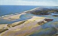 areas that are now Nauset Inlet and the Town Cove. Massive blocks of ice and rock were congealed and mixed in the outwash plain at the edge of the glacier. Giant boulders and cobble rocks were dropped and left behind as the ice retreated. Today the massive boulders found along the shore of Nauset Heights, Nauset Marsh, Town Cove and Pleasant Bay are the remnants of that last ice age. Most notable of which is the giant boulder that displays the plaque describing the courageous journey of two men who rowed across the Atlantic from Nauset Harbor.
Nauset Indians
As the climate continued to warm small bands of native peoples (Indians we might call them) began to move northward into the region. These first people – small bands of hunter-gatherers – began to explore the low lying river bottoms, ponds and freshwater marshes that fringed the early post glacial Cape. As the sea continued to rise salt marshes, estuaries and tidal rivers developed (like Nauset Marsh) and the native peoples began to settle in large communities all along the shores of the Cape. Some time around 4,000 years ago a village began to develop along the shores of Nauset Marsh. These people of Nauset were skilled hunters and fishermen. Around 1,000 years ago they began to plant gardens of corn, beans, and squash along with their seaside settlement. Here they lived contentedly, waiting perhaps for Samuel Champlain and other Europeans to find them at the beginning of the seventeenth-century. In 1830 there were approximately 5 Nauset Indians registered with the Town of Orleans.
When Samuel de Champlain’s barque slipped through the passage at Nauset Inlet late in the afternoon of Jul 20, 1605, he found before him not a “New World”, but an ancient one. 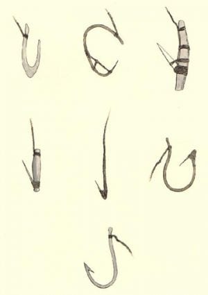 Here on the grassy hills bordering the marsh were the wetus (dome-shaped homes covered with colorful woven mats made from the grasses of the salt marsh) and cornfields of the Nauset people, whose ancestors had first come to the narrow land almost 10,000 years earlier.
The village at Nauset was home to several hundred people. Each family maintained a garden of corn, beans, and squash which surrounded their wetu. Within the wetu were cedar planks covered with furs for sleeping near the central fire. Wooden bowls, stone pestles, clay pots, grass blankets, and large clam shells used as skimmers or spoons were arranged nearby.
The women and children of Nauset spent the long summer days at home weeding the gardens, gathering shellfish, fishing, and playing in the cool waters of the inlet. The men of Nauset fished off-shore in large, open dugout canoes, or hunted in the deep forest beyond the borders of the settlement.
The long arrows of the hunters were tipped with tails of horseshoe crabs, sharpened bone, or stone. The Nauset fishermen used beautifully carved bone fish hooks for bass and cod. On summer nights the fishermen stalked sturgeon by torchlight in the shallow waters of the inlet and cove.
At the end of the long summer, the harvest was gathered. Corn was dried, placed in large baskets, and stored in pits dug into the sandy hills nearby. As the winter approached the families packed their belongings and moved to the sunny hillsides above the nearby ponds where they would be protected from the worst of the winter weather.
In the spring, when the alewives and osprey returned, the families would return again, to their homes and gardens on the hillsides above Nauset marsh.
Description by Fred Dunford, Historian
1600’s Mill on Mill Pond
Rocks were added to the Mill Race to accelerate the velocity of the water flowing through the opening to the pond, making it suitable for a hydro-powered mill. The mill was likely used to grind corn or wheat. Some cedar stumps still remain to identify the location of the mill.
1898 – French Trans-Atlantic Cable
In 1898 the French laid a Trans-Atlantic Cable directly to the Cable Station in the Orleans Town Cove. By this time there were many trans-Atlantic cables but this was the longest, single-span cable laid up to that time; a length of 3,173 nautical miles. It was laid by the French Cable ship, the François Arago. Stanley Holden remembers as a child the large French ship that was anchored off Nauset Inlet for several months while Frenchmen traveled back in forth in motorized dories attending to the cable and making repairs. The Orleans station operated until it was dismantled by the US Signal Corps during WWII. It was put back into operation in 1952 and finally closed in November 1959. What remains is the Orleans French Cable Station Museum on Route 6A.
Many Nauset Heights residents remember seeing a section of large diameter cable protruding from the sand at the bottom of the public steps in front of the big rock. This cable was not the trans-Atlantic cable but rather a communications cable laid between the Eastham Life Saving Station and the Orleans Life Saving Station which was where the Nauset Public Beach is now. To view maps of the various trans-Atlantic cables, or for more information click here: http://atlantic-cable.com/Article/FrenchCableStation/
1890 – Sand City
Summer cottages on the north spit of Nauset Beach called Sand City which belonged to 13 Orleans residents. Two of those cottages now reside on Nauset Heights; the McGee house and one near Deer Run Road. Another one was moved to the old Snow’s store. Another half-Cape was moved to Barley Neck , behind the Taylor Farm, but that one caught fire and burned to the ground. One of the last cottages to survive Sand City was owned by Stanley Snow and it was burned to the ground by accident during a beach party; the bon fire was too close to the house. Owen Calderwood witnessed it. The Orleans Fire Department could not get out onto the beach to put the fire out. Old beds and antiques were lost. All that remained were the fireplace, the toilet and a small donkey’s horse shoe, which is now hanging on a lamp over the mantle in Bonnie Snow’s house. Bonnie Snow remembers a stand pipe out in the water that came from one of the cottages. They had steep roofs, according to Owen Calderwood. The road over the beach which accessed the cottages at Sand City was a “corduroy road” made of trees split lengthwise and laid edge to edge – the flat side up.


1890 – Nauset Heights Subdivision
Around 1890 the area we call Nauset Heights was purchased by Fred and Robert Seaver. In 1915 the Seavers hired an agent named David L. Young and a surveyor named Arthur L. Sparrow to create a design for a subdivision, with named roads and 196 lots. Low resolution or high-resolution views of the map.

EARLY 1900’s
Old Nauset Heights Cottages
Today, there are a number of cottages remaining on Nauset Heights that are from the 1930s or earlier. The Kenna and Farnham cottages were among the first erected on Nauset Heights, along with the old Hunting Lodge that was originally a camp brought up from Sand City on Nauset Beach. Also among the earliest cottages were the Cunningham cottage, built in about 1915, along with the McGee cottage, the Calderwood cottage and the Hurlburt house. The Tucker cottage, “The Little House” is only 30 feet from the edge of the Bluff (shown at right). Other cottages have been torn down or moved over the past 20 years and replaced by more modern homes – some quite large.


1918 – 1970 Mayo’s Duck Farm
The Mayo land was devoted to duck and capon chicken farming. Their white and red flocks extended both southward off Beach Rd as well as over the hill to the west toward the Mill Pond and Grand View. There were acres of them and white feathers could be seen everywhere. Even the duck feathers and down were sold. According to Edgar “Red” Spear there were over 30,000 laying hens and they hatched over 50,000 ducklings annually that were slaughtered and sent to market. Early pictures show that trees were almost non-existent. At the top of the hill across from where the Ship’s Knees Inn is now, there was a large water tank tower that supplied water to the entire farm. In those days foxes were a problem and Mr. Mayo paid $5 for any fox shot on the farm.
The Mayo Farm kitchen supplied thick duck and chicken sandwiches for the fishermen as well as squash rolls and huge Joe Frogger cookies for residents. Bobbi Tucker remembers riding her bike up the hill to Mayo’s farm to fetch a fresh pie for dessert. Her father would give her $1.50. For the most part, the ducks were kept on the south side of Beach Road and chickens were kept on the north side. From the Mill Pond looking up toward the hill, now Grand View Estates, all you could see were Rhode Island Red chickens and a few chicken coops. In the early years, children could “rent” a chicken or duck for the summer and take it home, returning it at the end of summer. Watch video

1918 U-156 Submarine Attack of Nauset Beach
The German submarine, U-156 fired upon a South bound tugboat and four barges approximately four miles off Nauset Inlet, sinking the barges. On the morning of July 21, 1918 U-156 positioned itself off Nauset Inlet. Armed with two torpedo tubes and 18 torpedoes as well as two 105 millimeter deck guns and 1600+ shells, the sub surfaced and opened fire on the 140 foot tugboat, the Perth Amboy and four barges. The tugboat was struck but did not sink. The tugboat personnel were rescued at sea. John Botovich, an Austrian born mariner and member of the crew was struck in the arm by one of the 50 rounds that were fired at the tug. The injury was so severe that his arm was nearly severed.
According to Reuben Hopkins who was in the lookout tower at the Nauset Beach Coast Guard Rescue Station (at Nauset Public Beach) he saw an enemy shell explode over the tugboat. The tug was sinking quickly. Then the sub started firing on the barges. The crew of the tugboat included 32 merchant sailors and civilians, including the captain’s wife and children. According to Robert Cunningham, the Hurlburt cottage, “Sea Feaver” was used as the “medical relief” house for those on the tugboat. A doctor lived there. There are still rumors that the cement lump in the side yard there holds the exploded remains of a German shell.
A call to the Chatham Naval Air Station informed them of the ongoing U-boat attack. A Curtiss HS-2L and R-9 seaplanes were dispatched and they dropped a depth bomb on the sub but it did not explode. One of the pilots, Charles Webber then threw various tools from his tool box onto the sub, including a monkey wrench. After the incident a few shells and craters were found on shore, some were also found in a nearby marsh. The effects on the population of Orleans were immediate. People began reporting the hearing of naval battles off the coast.
A sign was erected at the Bluff depicting the event. Children in the neighborhood set up a table near the sign and charged spectators 10 cents to look over the bluff at the site where it all happened. They had a chicken in a cage with a sheet over it and for 10 cents you could see “the chicken that survived the sub attack”.
U-156 was launched on April 17, 1917 and commissioned under Konrad Gansser. On June 15, 1918, with a crew of 77 she passed through the North Sea, negotiated the Northern Passage around the northern end of the British Isles, and out into the Atlantic Ocean where she sailed for Long Island. She then proceeded to New York Harbor where she had been ordered to lay mines. Records show that she was to lay a field of mines in the shipping lane along the south shore of Long Island, just east of the Fire Island Lightship. A mine laid by the U-156 is often credited with the loss of the cruiser USS San Diego, ten miles off Fire Island. The U-156 had meanwhile headed north to attack the US fishing fleet. She sank 21 fishing boats in the Gulf of Maine area, from Cape Cod to the Bay of Fundy, ranging from the 72 ton Schooner Nelson A (4 August) to the 766 ton Domfontein (2 August). On 20 August the U-156 captured the Canadian trawler Triumph south of Nova Scotia. They manned and armed the vessel and used it in conjunction with the submarine to capture and sink 7 other fishing boats in the Grand Banks area before eventually scuttling the Triumph. The U-156 was presumed to have struck a mine in the Northern Barrage minefield and sunk in the North Atlantic. For more information click here: http://en.wikipedia.org/wiki/SM_U-156


1920’s – Utilities
Electrical services in Orleans and on Nauset Heights began around the 1920s.
1923 – 1928 – The Nauset Cup
In the 1920s a group of teenagers started a tennis competition which lasted for years. Played on the old grass tennis court owned by Mr. Jarvis on Nauset Road the winner of the tournament each year was awarded the Nauset Cup; a beautiful brass trophy that they would take home for the winter. Winners included Fiske Rollins, Bill Farnham Sr., Steve Tyng Sr. and Joe Tenney Sr. The trophy still remains with the Tenney family as a keepsake, as Joe Tenney Sr. was the last recipient.
The tradition continues. In 2008 a new Nauset Cup competition was started. On July 4th, the winner of the Nauset Heights Fun Run; a 2.2 mile run through the back roads of Nauset Heights was awarded this elegant Cup which stands 2 feet tall. The 2008 Nauset Cup winner was Alex Calderwood, from a field of 109 participating residents. The Cup will be awarded to the winners each 4th of July.


Party-Line Telephone
In the early years of the telephone service houses along the Bluff had a party telephone line; maybe as many as five families on one line. The local phone number for these five houses was 1129. Each house was designated by a letter, like 1129-W, 1129-R. If an incoming call was for the Howe family the phone would ring five times in succession, followed by a pause, and then five more times. To make an outgoing call you would have to wait until nobody else was using the line. All of the calls went through a central switchboard at what is now the new TD Bank North building in Orleans. To make a long-distance phone you had to first call the operator and they would connect you. According to Walter Mayo, “The chief operator in the 1950s was Charlotte Ormsby, a formidable woman who (if I was calling home) would say ‘Your mother is in town at the A&P’”.

1925 Sub US S-19 Ran Aground at Nauset Inlet
Another submarine story, less know, is about the US Sub S-19 that ran aground on a bar just outside Nauset Inlet, directly in front of the Tenney property. The US Government hired a salvage company to rescue the sub and tow it back to sea. To do this they erected a large pulley system with an anchor at sea and a giant winch erected in the Tenney’s front yard. When the winch cable was tight, pulling the stern of the sub in the seaward direction explosives were used to disrupt the sand under the hull. This was done at high tide. As soon as the propeller was in deep enough water they used the sub’s engines to assist in the effort. Eventually the sub was freed. The preparation for this endeavor took two months to set everything up. The Government paid the salvage company by the hour, so the contractors were in no hurry to get the job done and they used all of the allotted time. A letter to Mr. Tenney from the Merritt-Chapman & Scott Corporation (the salvage company) dated March 24th, 1925 states that the S-19 was floated and the project was complete. It said that the spare key to the garage had been tied to the pump handle and put inside the garage. Where the pipe from the pump was cut it had been put back together with a galvanized union and all other damages from the operations have been repaired to Mr. Tenney’s satisfaction. For more information click here: http://en.wikipedia.org/wiki/USS_S-19_(SS-124)
1927 – Montclair Shipwreck on Nauset Beach
According to resident historian William Quinn, the photos to the right are probably of the wreck of the Montclair, which grounded and came apart in a gale off Nauset Beach on March 4, 1927. It then disappeared until reemerging from Nauset Beach in 1957, then again in November 2010, and once more in November, 2011. The wreck can be seen just East of the south end of the Nauset Beach parking lot. The 2010 photo shows several keel ribs with interior bilge planks attached. The wreck is slowly being buried once again, but can be viewed as of this date (12/31/11). (Robert Cunningham)
1935 – Roads on Nauset Heights
The first paved roads on Nauset Heights began in 1935. Nauset Heights Road was not paved until after 1942. Utilities such as town water were added in the early 1960s.

1936 Cliff Road
Cliff Road was a viable road in 1936, according to Owen Calderwood. He remembers driving all the way down the Bluff to the beach at Priscilla Landing. Bobbi Tucker recalls that some of the cottages along Nauset Bluff had their driveways off of Cliff road, including her own property; a narrow dirt road that ran along the bluff between the houses and the sea. Cliff road began south of Callanan’s Pass and went down the hill along the Bluff to the little beach facing Tonset shore; now called Priscilla Landing. In the mid 1930’s kids would play in the grass on the ocean side of the road. Cliff Road and the field on the seaward side have been lost to erosion. The Tucker cottage, “The Little House” sits only 30 feet from the edge of the bluff. For most of the houses along Nauset Bluff, their driveways now comes in from Standish Road or Nauset Road. New driveways were added in the 1940’s when Cliff Road became too dangerous to travel and Standish Road and Nauset Road were still a dirt roads. Cliff Road was finally closed in the mid-1940’s due to erosion. On old maps you can see Cliff Road. The Calderwood family uses what’s left of Cliff Road as their driveway off Nauset Road. Alden Road on the west side of Priscilla Beach was once part of Cliff Road. When Cliff Road collapsed and was closed they named the remainder of the road “Alden”.
1930 – 1940 Williams Horse Stable
Sue Williams Spencer Miller summered at 4 Standish Rd on Nauset Heights. During the summer she brought her horses from home. The three-horse stable in the back of the property is still there, used primarily as storage for water skis and boat supplies. She enjoyed riding on the beach and around Nauset Heights.
1940’s – Radio
There was no radio reception of any kind until sometime in the late 1940’s
1953 – Nauset Heights Association was formed
Rum Runner Aground on Nauset Beach
Owen Calderwood witnessed a “Rum Runner” with 2 large, Lincoln engines aground on Nauset Beach. He says they ran under the cover of the night; very loud engines, like a PT boat. Not sure of the timeframe.
Nauset House Hotel
Some people have said that the original third floor of the Kenna house used to be the Nauset House Hotel. Bill Burling has a map of Nauset Heights which clearly indicates that on that spot there was a “Nauset House Hotel”. It says so in black and white. But according to Nancy Callanan Barker (her father was the original owner of the property) there was never a hotel there. It just seemed that way because there were many summertime visitors. For more details see the Cottage History of the Callanan/Kenna cottage.
Hunting Lodge
Captain David Young (not a real captain, but he was a fisherman and lobsterman, as was his father, Bob Young), father of Alein Owen, built a hunting/fishing lodge on Nauset Heights which people referred to as “The Camp”. It was one of the very first cottages on the Heights and it is believed to be one of the camps from Sand City which was moved up to the Bluff from the beach. It was believed to have been sold by Alein to the Eschert family around 1965. Jack Mahaney has an old soap stone sink from the property with the date 1910 written on the bottom.

Water Tower
There were two windmill water towers on the Bluff; one was at the Hunting Lodge and one was at the cottage owned by the Calderwoods. The cement footings for a tower still exist on the Calderwood property.
Humane Society Shacks
The Humane Society erected life-saving shacks along the shores of Cape Cod for shipwrecked mariners. The contents of these shacks contained water and basic food provisions and a sleeping cot. Some may have also included a small rowboat. These provisions were intended to sustain life until someone until rescued.
Coast Guard Life Saving Boat Houses
There was one at Priscilla Landing and one on Surf Boat Lane. They disappeared around 1950. They were always unlocked, stuffed with life jackets, a double-ended rowboat, and about 20 oars.

“Moon Cussers” – Beachcombers
“Moon Cussers were people who combed the beaches after a storm looking for debris from shipwrecks.
WAR YEARS, WW11 1941-1943
1940 – 1943 Gasoline Rationing
During WWII gasoline was rationed for the war effort. It was almost impossible to get gasoline. People traveling to Nauset Heights for the summer from a distance had to collect and save gasoline for some time in order to fuel their vehicle for the long drive. Only military people could get gasoline easily, and only if it were for emergencies or war-related. They had to show a military ID. A few people living on Nauset Heights had military IDs. Everyone else needed a special sticker on their car; either “A” or “B”. If you had an “A” sticker you were allowed only 3 gallons of gas at a time. If you had a “B” sticker you could purchase more than 3 gallons at a time.
Since gasoline was rationed, Marcia (Gertrude) Howe and her three daughters rowed from the Nauset Heights harbor all the way into the Town Cove for supplies once a week. That’s a long way. Naturally, they used the tide in their favor, but the trip was a long tiring one. In their cottage, the food was stored in an ice box, right next to the two-burner kerosene stove and not far from their row of canvas collapsible army cots.

1940 – Taking the Train from NYC
During the war years Marcia Howe and her family took the train from NY City to Orleans with all of the family baggage and the dog, Reddy, for the summer. The train stopped where the bicycle rental shop is now and Don Walsh, smoking his corn cob pipe, drove them in his flat bed truck to the Heights. Sometimes Mr. Howe would drive up to the Cape in his bright yellow Packard. The trip would take 12+ hours. The Nauset Heights roads where not paved yet. They were very bumpy.
1943-1944 Covering Windows During Wartime
Residents along the Bluff had to observe strict light discipline at night and cover all the windows so that the German submarines couldn’t see any illumination. If they could see a spot of light they would have likely shot at it with their 105-millimeter guns. Capt. Joe Tenney from Nauset Heights was the “window warden” and he would patrol the houses along the Bluff, making sure that lights were out and windows were covered. He would walk along the beach below the bluff and look up to see if he could see any violations. The windows had to be completely covered. Mr. Tenney’s father, Arthur Tenney made and sold shades and awnings and would offer his services to erect a blind for those that needed it. Many Bluff residents bought his “blackout” blinds.
1942 – 1943 German Raft Discovered
One early morning a Nauset Heights fisherman, Dr. McPherson was walking the beach in the fog and discovered some tracks in the sand which led up to the dunes. He found a German submarine raft and footprints. He immediately reported his finding to the local authorities. Later that day, two enemy submariners were caught looking for food. Nobody was hurt. I am sure there are newspaper articles about this somewhere.
1940’s – Walking to the Theater
The Orleans Movie Theater was located where CVS is now and the Howe children would walk from Nauset Heights to the theater in bare feet, about 5 miles, clutching their 25 cent admission.
1946 Softball Games on the Bluff
Gill Croll organized softball games at the Tenney property on the Bluff. The baseball diamond was such that a ball hit into the outfield would go right over the bluff. Girls could hit with their normal hand, boys had to hit with their opposite hand. If you hit the ball over the bluff – YOU WERE OUT! Only one person managed to hit the ball over the bluff and that was Gill Croll himself.
Shipwrecks
According to Bobbi Tucker, one ship broke up just offshore, perhaps from enemy action. It was filled with shelled walnuts from India. These washed onto our beach for a long time, turned rotten, and smelled really bad.
POST WW11 YEARS
1950 Formation of the Massachusetts Beach Buggy Association
At the Public Beach parking lot, in 1950 a group of fishermen got together and formed the MBBA; the Massachusetts Beach Buggy Association. Among them was Bill Farnham.
Using “beach buggies” to travel the beach was a necessary part of fishing for stripers, allowing fishermen to access areas of the beach that were otherwise too difficult to get to.
This group of fishermen felt there was a need for an organization to regulate beach buggying and establish a set of rules and policies, and therefore started the Association. To this day the group promotes safe beach access and conservation as well as saltwater fishing.
http://www.mbba.net/
1950 – 1960 Harry Hunt – Lobsterman
Harry Hunt was a colorful lobsterman that would go back and forth through Nauset Inlet in his lobster boat; the Gertrude T, named after his wife, who was an Eskimo. You could hear his words of profanity from the bluff… always with a smile. The kids loved to belly-board in the huge waves created by his wake. He sold lobsters out of his garage on Tonset Rd.
1960’s Fishing Net Across Nauset Inlet
Bruce McFarlane of Orleans bought a 100’ long fishing net in Nova Scotia and with the help of an accomplice attempted to string it across Nauset Inlet one night to catch a huge number of Stripers on the outgoing tide. The net quickly became over-weighted with seaweed and other debris and collapsed at both ends, washing out to sea. He’s probably not the first to try it.
1960’s The Pendelton Shipwreck Rescue
The Pendelton went aground in a storm and broke in half. It could be seen best from the Chatham Lighthouse. For information: http://www.cg36500.org/history_pendleton_rescue.html
1960’s Fireworks on Nauset Public Beach
Fireworks at Nauset Public Beach were particularly beautiful in the sea fog as we remember. In the 1970s, Jess Tucker found an unexploded professional explosive from the Public Beach fireworks. It was the size and shape of a coffee can. The neighborhood kids hung the explosive from the signpost at the end of our driveway and lit it. The explosion was so intense it rocked the houses nearby, causing residents to wonder come outside, and see what happened. Thankfully, nobody was hurt, but it was a good lesson for those standing nearby when the thing went off. BOOM!
1964 – Fighting Chance Row Boat
There is a large glacial rock in front of the Nauset Heights Association steps on Nauset Bluff where a pair of British men set sail in a row boat for France. Their first attempt out the Inlet failed and some local lobsterman rescued them and helped repair a few leaks. The second attempt was successful and the harrowing trip finally took approximately 4 months; all of it during hurricane season. There is a bronze plaque on the rock telling the story. Today, the rock is almost buried in sand, as the sands have shifted over time. Periodically, residents go down to the rock with a shovel and uncover the top to display the plaque. Perhaps one day it will be magically exposed once again by the ocean, surprising future generations.

1974 Rescue at Nauset Inlet
Jess & Link Tucker were boating around Nauset Harbor during a September Nor’ Easter and saw flashing headlights at the Point. As they got near they saw that several fishermen were drawing their attention to a small Whaler overturned in the mouth of the Inlet on an outgoing tide. The waves were 10 feet tall and right in the middle of it all was an upside-down boat with the propeller sticking straight up. It had flipped over in the big waves and the anchor had escaped the bow compartment and secured it in place on the sandy bottom. As they got closer they saw a man in his 70’s and a young boy and a dog hanging on for dear life. The man had one arm around the outboard motor and the other arm around the boy and had the dog by the collar. It was a desperate situation and they were 200 feet from shore. The water was ice cold.
Jess maneuvered his boat close enough so that Link could throw them a line which the man tied around the boy. Link pulled the boy into the boat with the dog but the man was losing his grip. Quickly, Link threw the line out again and the man tied the rope around himself and was saved. He almost didn’t make it. The outgoing current was extremely strong and the Whaler was stuck in the trough of a 10-foot standing wave.
The man, the boy, and the dog were delivered to the beach and some fishermen wrapped them in blankets and took them directly to the hospital in Hyannis. The Harbormaster arrived and tried to save the boat but as soon as he uprooted the anchor the bow of the Whaler dug deep into the water like a wedge and began to pull outward. The Harbormaster’s boat was no match for Mother Nature. The line snapped and the Whaler and all of its gear traveled quickly out the Inlet through the storm surf. The boat was a total loss. The crew was saved.
1984 Eldia Shipwreck
One stormy night (March 30, 1984) a local fisherman named Mike Kartasiewicz spotted a small light on the top of the mast of a large freighter drifting slowly by, along the beach, very close.
It was the Eldia. It’s engines had failed and it drifted along Nauset Beach, settling in the sand ½ mile south of Nauset Public Beach. It was said that the Army Corps of Engineers was going to cut the 473 foot ship into pieces and remove them one by one along a makeshift beach road. The ship was freed. It is awesome to see the entire hull of a big ship exposed. Reference: http://www.capecodtoday.com/blogs/index.php/2009/03/29/1929-katharine-lee-bates-1984-eldia-come?blog=161

1980’s Nauset Heights Revetment Project
After a few large storms, it became apparent to most Nauset Bluff residents that further erosion was going to be a problem. Seeing a sturdy wall being built on the Tonset Shore led to discussions about preserving the Nauset Bluff. Many of the Bluff residents met at the Calderwood house with a local engineering firm to discuss the possibility of building a stone revetment along the length of Nauset Bluff. Ultimately, the cost was prohibitive, and any permits to build such a structure would be extremely difficult to get, especially after the National Seashore took ownership of much of the shoreline below the bluff. The cost estimate was approximately $1,000 per linear foot, and the wall would have extended more than 500 feet. Besides, we learned that the sea is really too powerful to hold back, no matter how much money you throw at it. We calculate that we probably lose about a foot of the bluff edge every decade on the average. In that October No Name storm, we lost 7 feet of our bank.
1991 – The No Name Storm
Nauset Heights residents were standing at the top of the steps during the peak of the No Name Storm (October 1991) and witnessed the largest surf they had ever seen – 30’ waves breaking on the beach and the tide was nearly ½ way up the Tyng’s steps, which is about 13’ above normal high tide. The wind was so strong standing at the top of the bluff they could lean forward about 30 degrees without falling. The windows in the Tucker Studio cottage were bowing inward at least 1”. Impressive!
Other memorable storms were Hurricane Bob (1978), the Blizzard of ’78, the 1944 hurricane, and the 1938 hurricane.

THE BEACH
Beach Evolution
In the early 1930’s the cut (or inlet) to the ocean was directly in front of Nauset Heights. Some earlier pictures show the northern-most tip of the beach in front of the Farnham residence. Over the past 80 years the inlet has moved North, sometimes breaking free in the middle, and then moving North again. It is evolving. Likewise, the sea is evolving; the seals are making this place their home and eating all the sand dabs that we used to love to catch with a piece of clam and weighted line off the back of a row boat. And commercial shell fisherman have almost completely cleaned out the musseles, although some say this is due to other factors. It was such fun to go to the bottom of the steps and bring up a bag of mussels for an evening snack. The beds are nearly totally cleaned out now.